Alfred Gould’s House - Sourisford - Historic Places Days

Alfred Gould’s House – Sourisford

Coulter, Manitoba
Type
Geocache
Address
The park of destiny, Coulter, MB, Canada
Get directions
Hours
24/7

This Geocache site is brought to you by the Turtle Mountain Souris Plains Heritage Association. Lat: N 49°08.024′ Long: W 101°00.480′. Note that the map may not be completely accurate. For exact directions to this location, search Google Maps using the coordinates given, or visit vantagepoints.ca and geocaching.com. Site description from Canada’s Historic Places website.

Sourisford (Coulter) Park is located at the junction of the Souris River and South Antler Creek, just south of the Boundary Commission Trail and north of Coulter
The organized park space contains recreational and heritage structures, surrounded by a natural landscape of trees, shrubs and prairie grasses.

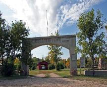
View the formal memorial archway at the entrance, of reinforced concrete construction, with ‘COULTER PARK’ and ‘1929’ inscribed at the top, additional inscriptions in honour of Francis Coulter and the original members of the Arthur Pioneers Association, etc., plaques commemorating the history of the area, and nearby a portion of a paddlewheel built by H.R.J. Larce for the `Empress of Ireland’, a boat used on the Souris River.

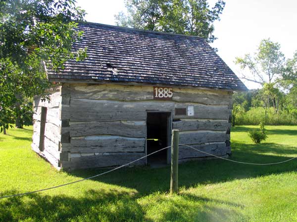
Visit a ca. 1885 log house, recently restored, and a 1 1/2-storey fieldstone house (1902) built by Alfred Gould and retained in situ on open prairie  near the park’s other facilities.

Enjoy amenities for camping and picnics, playgrounds, a performance stage, etc. The site is fully accessible to the public.

Amenities

  • Family-Friendly
  • Parking
  • Pet-Friendly
  • Washrooms

Location

The park of destiny, Coulter, MB, Canada
Get directions

Nearby Places

The Empress of Ireland

Coulter, Manitoba
Geocache near village of Coulter MB Lat: N 49°05.322′ Long: W 100°59.039′
View Place | Get Directions

Linear Mounds National Historic Site

Coulter, Manitoba
Linear Mounds was designated as a national historic site of Canada
View Place | Get Directions

Brockinton Bison Pound

Manitoba
Archaeological site in the RM of Two Borders. Lat: N 49°12.067’ Long: W 101°02.011′
View Place | Get Directions

Copley Anglican Church

Manitoba
Historic site within Municipality of Two Borders. Lat: N 49°01.805′ Long: W 101°15.114′
View Place | Get Directions

Register A Place

Create an account to add your historic place.

Make a VisitList

Welcome! To get started on a VisitList, you’ll need to have an account with #HistoricPlacesDays.


Already have an account? to sign in.
We use your contact information to process your registration and correspond with you about the National Trust and its programs. You can unsubscribe at any time. We care about your privacy. Read our privacy statement.

Sign In

Sites that participate in #HistoricPlacesDays need to have an account.

Welcome! To get started on a new VisitList or to edit an existing one, you’ll need to have an account with #HistoricPlacesDays. Sign in below!


Not registered? Click here to create an account.

Forgot Password

Enter your email address to request a password reset.


to sign in.

Get the latest scoop on everything #HistoricPlacesDays – join our e-newsletter and never miss a beat.