Ridge Road Heritage Trail - Historic Places Days

Ridge Road Heritage Trail

Yukon
Type
Park/Landscape
Address
Ridge Road Heritage Trail Trailhead, Upper Bonanza Creek Road, Unorganized Yukon, YT, Canada
Get directions
Hours
Always Open
Phone
867-667-5386

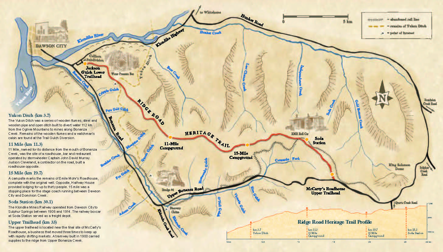
The Ridge Road Heritage Trail follows the route of the first publicly funded road in Yukon. It was built in 1899 and supported by William Ogilvie, then commissioner of the Yukon. The controversial road followed the ridge between Hunker and Bonanza Creeks, two of the richest in the Klondike. Miners in the valleys complained about steep grades and roundabout routes, and the road was soon superseded by new roads in the valley bottoms although some sections remained in use for far longer.

There are significant historic remains along the Ridge Road including the foundations and artifacts from numerous roadhouses, which formerly served travelers. There is also Soda Station Boxcar, a railway boxcar which was stripped of its undercarriage and used as a small station building on the short lived Klondike Mines Railway (1906-1914). The Yukon Ditch was a massive placer mining  project built in 1906-1909 to bring water to the gold fields and create electricity. It operated until 1933. Trail Gulch is a point at which water was diverted down slope and is located just off of the Ridge Road.

Since 1997 the northern 33km of the Ridge Road are maintained as a heritage trail by the Government of Yukon. Its lower trailhead is located behind Callison Subdivision while the upper trailhead is on the Upper Bonanza Road near King Solomon’s Dome.

Amenities

  • Family-Friendly
  • Parking
  • Pet-Friendly
  • Washrooms

Fun Facts

  1. Built in 1899 the Ridge Road was the first publicly funded road in the Yukon.
  2. The Ridge Road was originally 56km long. Today only 33km are maintained as a heritage trail.
  3. Miners in the creek valley’s called the Ridge Road the “parachute road” because of the steep hillsides.

Location

Ridge Road Heritage Trail Trailhead, Upper Bonanza Creek Road, Unorganized Yukon, YT, Canada
Get directions

Nearby Places

Dredge No. 4

Dawson City, Yukon
Symbolizes the importance of dredging operations in the Yukon from 1899 to 1966.
View Place | Get Directions

S.S. Keno National Historic Site

Dawson City, Yukon
Riverboat that played a major part in the history of the Klondike Gold Rush.
View Place | Get Directions

Old Territorial Administration Building National Historic Site

Dawson, Yukon Territory
The heritage value of the Old Territorial Administration Building lies in its associations…
View Place | Get Directions

Dawson Historical Complex National Historic Site

Dawson City, Yukon
Site commemorated for its association with the Klondike Gold Rush from 1896 to 1910.
View Place | Get Directions

Register A Place

Create an account to add your historic place.

Make a VisitList

Welcome! To get started on a VisitList, you’ll need to have an account with #HistoricPlacesDays.


Already have an account? to sign in.
We use your contact information to process your registration and correspond with you about the National Trust and its programs. You can unsubscribe at any time. We care about your privacy. Read our privacy statement.

Sign In

Sites that participate in #HistoricPlacesDays need to have an account.

Welcome! To get started on a new VisitList or to edit an existing one, you’ll need to have an account with #HistoricPlacesDays. Sign in below!


Not registered? Click here to create an account.

Forgot Password

Enter your email address to request a password reset.


to sign in.

Get the latest scoop on everything #HistoricPlacesDays – join our e-newsletter and never miss a beat.